Mapping 101: Aligning Historical Maps and Visualizing Geographic Data
Selecting a map.
- I was fortunate to find a gorgeous, high-resolution image of a historical map of Paris on Wikimedia Commons. The image is provided by the dealer Geographicus Rare Antique Maps.
- The Parisian firm Hachette published the map, titled Nouveau Plan de Paris Divise en Vingt Arrondissements, in 1870. The pocket map shows all of the city’s 20 arrondissements, or administrative districts, in different colors. The city expanded from 12 to 20 districts, in 1859, through the annexations of an outer ring of suburbs.
- The map is ideal for my project because all of the paintings that I study date to the 1870s. This decade also coincided with the completion of the urban renewal and greening of Paris, with an exponential growth of the French horticultural industry, and with the emergence of a commercial art market that increased the flows of artworks and reproductions of them.
- You can find maps of Paris in the BnF’s Gallica database and discover all kinds of historical maps in the David Rumsey Map Collection.
Warping a map.
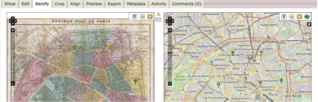
- I used the free web-based application Map Warper to align the historical map of Paris to existing latitude and longitude coordinate systems.
- It’s easy to create an account and upload a map. Then, you place roughly 10 control points on the map that tell the application how to warp or rectify it.
- This Map Warper Tutorial walks you through the process step by step.
- My map is now available on Map Warper for other scholars to view and download.
Plotting data on a map.
- I use ArcGIS to plot data with geographic coordinate values on the rectified map of Paris.
- ArcGIS allows users to import, analyze, and display maps and data sets.
- I also use the ArcGIS geocoder to match the street addresses in my data sets to coordinate values. (Note: This process is complicated because historical street names do not necessarily match contemporary addresses. More on this issue in a future post!)