The Big Idea: Art | Gender | Plants | Urbanism | Movement | Networks | Power Structures | Ecologies
Why use mapping and historical geocoding to visualize data?
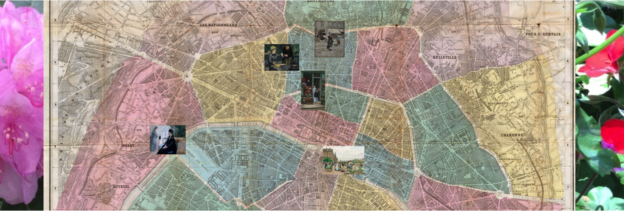
- I use mapping and historical geocoding to enhance close readings of five paintings by Paris-based artists of the 1870s.
- By combining traditional art historical approaches with methodologies drawn from geography and urban studies, I interpret paintings in ways that advance a feminist project to posit an alternative to the separate spheres model.
- I also respond to scholars’ tendency to gloss over the significance of paintings of women who appropriate, aestheticize, and domestic “exotic” and “tropical” plants in the wake of French imperialism and colonialism.
What makes the paintings good candidates for mapping?
- The paintings show modern life scenes of urban spaces where Parisian women marketed, transported, grew, arranged, and displayed ornamental plants (i.e. an outdoor flower market, a florist shop, a square, a home, and a domestic glasshouse).
- Because the artists thematize female and plant mobility at actual locations, I am able to map these horticultural sites and their proximity to commercial and civic green spaces.
- The transregional flows of the types of flora pictured, including fuchsias, pelargoniums, and nepenthes—autochthones of Central America, southern Africa, and Southeast Asia—can also be mapped.
What aspects of the paintings and horticultural networks does mapping illuminate?
- I demonstrate how the paintings articulate societal perceptions about the freedom of movement that women gained when transporting ephemeral blooms at commercial and to domestic sites.
- I visualize how male-dominated European power structures facilitated the collection, transport, propagation, hybridization, and sale of plants and how this commercial model relied on female merchants and consumers to distribute fresh flora.
- I reveal how certain paintings clarify an underexplored entanglement of Parisian female mobility with local and global plant movement patterns.